Written By: Heather Buckingham
Skookumchuk is a magical place. Nestled on the west coast of BC at the narrowest point of the Sechelt Inlet, flooding tidal waters rush past the constriction and form a truly spectacular wave at peak tides, while ebbing flows create giant whirlpools. Both features have been known to claim the lives of unlucky seafarers. One can only imagine what the first peoples or explorers would have thought of this place and the awe-inspiring power that it displays.
An abundance of sea-life thrive in this dynamic environment. Kelp clings to the sea floor, laid out like streamers in the moving waters. Purple starfish hide among crevices in the rocks, while barnacles, muscles, and sea anemones abound in the intertidal areas. In the fall, sea lions surf the waves, sometimes breaching next to kayakers, or popping their heads up in the eddies downstream. Even orcas have been known to make an appearance.
In the summer months, this is a huge tourist destination, and there will often be crowds of people on the shore cheering you on as you nail tricks or beater spectacularly. Motor boat operators also take tourists on joy rides to watch the wave, and navigate the rapids. Occasionally a float plane will buzz by for a view as well. In the fall, winter, and spring seasons, the tourists become fewer, and sometimes you can be the only one out there, finding solace in ultimate soul-surfing sessions.
Getting there
While technically part of the mainland, the Sunshine Coast is only accessible by ferry from either North Vancouver or via Powell River. From North Vancouver, the ferry to the Sunshine Coast takes about 40 minutes, and drops you off in Langdale (near Gibsons). From here it is about an hour drive along a windy but scenic road to get to Egmont, the village nearest the wave. Coming from Powell River (ferry from Comox on Vancouver Island to Powell River), it is about a half hour drive to Saltery Bay, where one would need to catch another ferry to Earl’s Cove through beautiful island scenery and mountainous backdrops. From Earl’s Cove, Egmont is only 15 minutes away.
There are two ways to get to the wave – by water or by land. To approach by water, one would put their craft in the ocean at the docks in Egmont Village. It is about a 4km paddle, and with the tide, should take about 45 minutes to get to the point. Along the way, you will pass by an old shipwreck on the island just beyond the marina. The boat lays nearly on its side, its mast rising out of the water – an ominous warning for sailors that these waters are dangerous. Paddle on the Egmont side of the inlet until you see a lighthouse on a small island. The wave forms by the rocky point across from this landmark. If the wave is in, you can’t miss it.
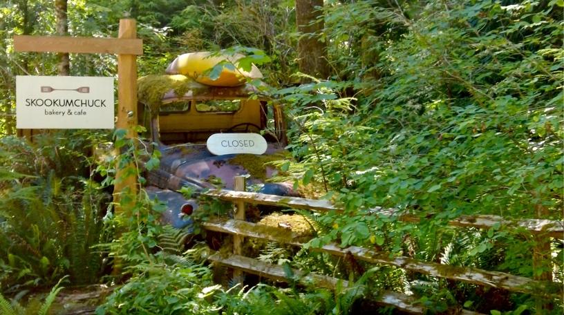
If going by land, there is a well-signed trailhead across from the museum, which is a short way up the road from the marina. It is about a 4km hike in down a well-developed trail. Near the start, you will pass by an excellent bakery on the hike in (well worth a stop if you have time!). The trail weaves through the coastal temperate rainforest, the majority of which is second-growth. Remnants of the old giants remain, and in places you can see where loggers once cut steps into old trees to help fell them. It is a healthy and vibrant forest, full of cedars, salal, and huckleberries. The woods are alive with the sounds of birds and other critters, and on a sunny day, the sun shines down through bright green moss, illuminating the place brilliantly. In the rainy season, the mushrooms pop up in stunning number and diversity.
Logistics
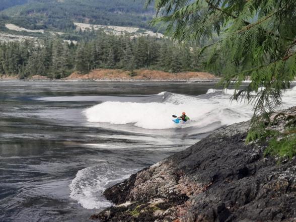
Unlike planning for a river trip where flows vary and can be unpredictable, the ocean operates on a very organized schedule, so it is easy to plan for the perfect tide even a year in advance! The tide prediction table I like to use is http://www.dairiki.org/tides/monthly.php/scl. The chart shows what phase the moon is in, which ultimately determines the size of the tides. Turn represents “slack tide”, when the ocean is neither flooding nor ebbing, but is about to transition from one to the other. This happens at low tide or at high tide. Max is the time when the fastest flows are occurring – either flooding (F), or ebbing -(E), measured in knots. The wave only forms on the flood tide when the Max is faster than 10 knots. During the ebb, big whirlpools form off a nearby point. Each day, the tide turns about 40 minutes later than the day before, so you can plan your trip in accordingly.
You want to arrive at the wave a couple of hours before “peak flows”. We like to paddle in at or just before slack tide to get there early enough to watch the wave grow. The bigger the tide, the faster the wave will grow and change shape!
The wave is good to surf in a variety of crafts, from sea kayaks to play boats, depending on the speed of the flood tide. At the smallest tides, the wave doesn’t really form, but there may be a gentle eddy line to play on. At the biggest tides, the wave builds quickly from a gentle roller into a big foam pile and will then green out into a fast green giant. Long boats can enjoy some soul surfing on the wave as it grows and before it breaks. For playboats ideal flows are between 12 and 15 knots. Once the wave gets so big it loses its foam pile again (this happens around 15 knots), playboats have a harder time staying on, and it’s time to get out the faster long boats again.
If you flush off the wave, it’s best to catch the eddy as soon as you can. The faster the current, the harder it is to catch the eddy. If you miss it, you end up going on the “tour”, a long bonus rapid to get back to shore where you can paddle back up to the wave. It gets big and scary at fast flows with massive boils, crashing waves, and swirly eddy lines.
There is a boat rack hidden in the woods at the wave for people intending to stay and surf for multiple days (recommended), and don’t want to paddle or carry their boat back out each day. It seems like a safe spot but bringing a bike lock is recommended. Make sure to either hike out the rest of your gear or store it in a way that leaves space for others.

Camping
There is great camping for $15/night up at Klein Lake Provincial Recreation Site (10-minute drive from the trailhead), which is first-come first-serve. It gets very busy in the summer and can be difficult to find a site. The lake is great for swimming in and cleaning the salt water from you and your gear after a surf, but the road to the back is currently in rough shape.
Across the street from the Post Office in Egmont is a popular spot for the van crowd. During busy seasons, there is an outhouse in the field next to the road for your convenience.
Next to the post office, there is also a grassy area where you can set up tents for $5 a night.
For those looking for a more luxurious stay, there are also cabins for rent at the Backeddy Resort and Strongwater Campground.